
Understanding Informal Public Transport network characteristics
IPT networks have emerged organically in response to demand and opportunities, shaped by trial and error, the location of available terminals, and perhaps also coordination or ‘turf wars’ among operators. Over time, they may exhibit rigidities of their own, such as the establishment of terminals in consolidated parts of the city and the union/membership associated with key routes or corridors. As a result, in many cities the networks have stabilised, other than thos areas of new development and spatial expansion. They are understood by the people who learn how to navigate the mobility options. Now they can be mapped and presented as a network, and perhaps even optimised.
Background
In an attempt to better understand the scope and nature of informal transport networks, researchers and practitioners across the African continent have embarked on large-scale data collection and mapping campaigns over the last decade. The combination of GPS and mobile technologies has simplified the acquisition of spatial data on public transport networks, as exemplified in Nairobi [6], Cape Town [7], Maputo and Accra [8]. These initiatives have described the spatial organisation of informal transport routes and provided insights into the accessibility of different parts of their city by public transport. They have also highlighted the challenges of maintaining an up-to-date transport map in cities where services are predominantly informal.
These recent developments in data acquisition and data transmission technologies have had a significant impact on paratransit studies. Smartphones and other mobile devices incorporating GPS and sophisticated sensors have been used for both “active” and “passive” data collection approaches.
Active data collection methods refer to the involvement of numerators that register specific events (e.g. the departure of a vehicle, a passenger boarding, etc.) on a portable device. Less frequently employed “passive” methods consist of fitting a tracker on a vehicle without having an enumerator present onboard. This approach makes it possible to collect comprehensive movement data over a long period of time, but the raw data can be difficult to interpret as it misses useful information to understand the behaviour of the vehicle (e.g. presence of passengers onboard, traffic conditions, etc.).
TRANSITIONS did not set out to map IPT network characteristics and has relied on other sources and knowledge of local City Researchers to establish an overall understanding of IPT in each city. Passive GPS data collection was undertaken in relation to the fuel consumption surveys on specific routes. Through the passenger opinion surveys, the project has gained insights into typical passenger journeys.
Comparison of situations and perspectives from the TRANSITIONS cities
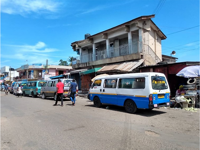
Network structures - The TRANSITIONS cities represent a range of situations in terms of network structure, organization and recent initiatives taken to map the paratransit routes.
Accra has a fleet of around 11,200 trotros (minibuses), as well as a greater quantity of sedans taxis (around 22,000), which operate as shared vehicles. In contrast, Cape Town, Freetown and Maputo rely much more on minibuses than sedan taxi vehicles. Overall, IPT represents about 19% of the modal share in Cape Town (or 54% as a share of the public transport passenger market, which may have increased with the complete collapse of rail services in the most utilised line in 2019), 62% in Accra, 65% in Kumasi, 55% in Freetown and over 33% (+ MyLove open trucks) in Maputo.
In Kumasi and Accra, the recent influx of other public transport modes such as the ride hailing services (Uber, Bolt, Yango etc.) and the three-wheelers typically used to provide these, have had a significant impact on congestion levels. Middle class users who used to take trotros can now opt for an individual mode of transport, which adds to congestion on the roads and increases air pollution. The lack of infrastructure such as bus stops and terminals has also been pointed out as a major challenge, which contributes to the shift to individual modes of transport and causes major road safety issue. In Kumasi for instance, many bus stops are used for trading activities which makes it impossible for commuters to sit while waiting for the next possible vehicle.
As Cape Town benefits from a more developed formal PT network, alongside the IPT minibus-taxi services, it represents an advanced case of where there have been efforts to integrate these modes. This has included physical integration approaches, such as improvement of IPT terminals co-located with PT interchanges, as well as professionalisation of IPT route associations to provide feeder services to high volume PT corridors. A notable example is that of the MyCiTi BRT scheme, which involved the amalgamation of eight minibus-taxi route associations to form the Kidrogen and Transpeninsula bus operating companies. This process followed a three-step process of: (1) rationalizing the transport network, (2) optimizing operations, and (3) renewing the fleet. The introduction of scheduled services in association with rationalised service routes (from 3 to 5 routes) and vehicle fleets (from 78 to 32 vehicles) contributed to improve services significantly, reduce the fuel consumption by 45%, and reduce the number of working hours for the drivers.
Accra has been one of the first cities to map trotro and shared taxi routes and make it available as Open Source data. However, this mapping exercise was partial as it only mapped the 315 routes originating from the CBD (Accra Metropolitan Assembly). This highlights the scale of the work required and another campaign was launched in 2021, mapping 110 additional routes across Greater Accra. Cape Town and Maputo have embarked on similar campaigns This data is essential for local authorities to understand how the network is structured, identify areas in the city that are not served, or potential competition with other modes of transport (beyond other regulatory benefits).
Further details on network characteristics, such as the presence of ‘floaters’ in Accra and Kumasi and ‘pirates’ in Cape Town (illegal operators) are provided here.
Multi-modal journeys using IPT – During the Passenger Opinion Surveys, respondents were asked which previous mode they used to reach the terminal, before continuing their journey by IPT. Walking typically represented a high proportion of trips, ranging around 26% in Freetown, 36% in Maputo and up to 46% in Accra. Linked trips by IPT, involving connections at the terminal, represented an even higher proportion of responses. This was as high as 67% in Cape Town, with other cities recording previous trips by minibus within the range of 30-50% (around 30% in Maputo, 40% in Freetown and 50% in Accra). While the locations of the terminals will have a bearing on these results (for example, whether the terminal is at the end of a key corridor, at a junction between several key corridors), overall it became apparent that a significant proportion of passengers are making multi-stage journeys by IPT in order to reach their destination. It can be assumed that people travelling from peripheral parts of the city will spend a significant amount of time each day commuting in IPT vehicles with low average speeds. Further research on trip costs and durations would be beneficial.

Figure: Mode used before entering the IPT vehicle - Kumasi
Main findings and messages
The scale of the IPT sector in Sub-Saharan Africa (e.g. over 400 routes and 33,000 vehicles in Greater Accra) is vast. Digital technologies provide the tools for planners to gain a better understanding of the networks for planning purposes, as well as to undertake more accurate quantification of benefits and problems. This will also enable more accurate cost benefit analysis and supporting evidence for the opportunities from working with the sector.
IPT is the major mode of motorised transport serving the metropolitan areas of Africa, providing a relatively efficient form of collective transport, but this continued dominance should not be taken for granted. Motorcycle taxis and private vehicle ownership are attractive to growing middle classes, but both will lead to greater congestion.
There is a need to support the sector, collect data and build capacities within local authorities to better organize the network (around well-planned terminals and stops) and avoid competition between operators. The challenge is tremendous, and the level of investment in public transport, as well as the integration of informal transport in the coming years, will completely change the future of these cities.
Further resources
-
Coetzee, J., Krogscheepers, C., Spotten, J., 2018. Mapping minibus-taxi operations at a metropolitan scale – methodologies for unprecedented data collection using a smartphone application and data management techniques. Presented at the 37th Annual Southern African Transport Conference Pretoria, South Africa.
-
Mapping informal bus routes ON VIDEO, posted on July 11, 2020, Trufi Association - https://www.trufi-association.org/mapping-informal-bus-routes-on-video/

Endnotes
6. Klopp, J.M., Cavoli, C., 2019. Mapping minibuses in Maputo and Nairobi: engaging paratransit in transportation planning in African cities. Transport Reviews 39, 657–676; AND Williams, S., White, A., Waiganjo, P., Orwa, D., Klopp, J., 2015. The digital matatu project: Using cell phones to create an open source data for Nairobi’s semi-formal bus system. Journal of Transport Geography 49, 39–51.
7. Behrens, R., Hawver, H., Birungi, C., Zuidgeest, M., 2017a. Case study investigation of unscheduled feeder and scheduled trunk service relationships in Cape Town. Presented at the 36th Annual Southern African, Transport Conference, 2017, Pretoria, South Africa; AND du Preez, D., Zuidgeest, M., Behrens, R., 2019. A quantitative clustering analysis of paratransit route typology and operating attributes in Cape Town. Journal of Transport Geography 80, 102493.
8. Saddier, S., Patterson, Z., Johnson, A., Chan, M., 2016. Mapping the jitney network with smartphones in Accra, Ghana: The AccraMobile experiment. Transportation Research Record 2581, 113–122.